
Tracking the Gulf Stream might seem easy if you live in Palm Beach County, Florida. If you stood on the shore in Lake Worth Beach, for example, and looked east across the Atlantic, you would be facing one of the most important ocean currents on Earth.
Just offshore (as close as two miles at times), a giant “river” of warm seawater is moving northward. It has no banks and no visible shoreline, but it carries enormous amounts of heat, affects weather on both sides of the Atlantic, influences hurricanes and sea level, and even helped shape world history.
That river is the Gulf Stream.
The Gulf Stream is a powerful warm ocean current flowing from the Florida Straits along the U.S. East Coast and across the Atlantic. The post explains its size, speed, role in moving heat, and influence on weather, climate, sea level, hurricanes, and marine life, especially in South Florida.
It also notes the current’s importance to Europe’s climate, its connection to broader Atlantic circulation, and its historical role in navigation, trade, and exploration. Benjamin Franklin’s early Gulf Stream map and the current’s use by sailors and pirates are also mentioned.
For us in South Florida, the Gulf Stream is not just something found in a marine science textbook. It is part of our local environment, and it helps connect our coastline to a much bigger global system.
What Is the Gulf Stream?
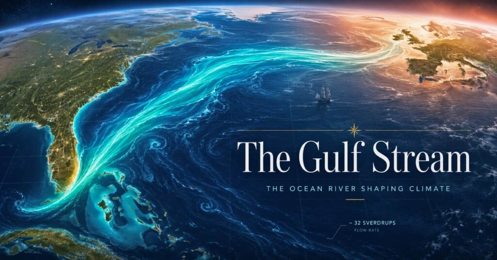
The Gulf Stream is a powerful ocean current in the North Atlantic. It begins as warm water moving through the Straits of Florida, between Florida and the Bahamas. From there, it flows north along the east coast of the United States before turning northeast and crossing the Atlantic toward Europe.
Scientists often describe it as a western boundary current, meaning it is the strong current that flows along the western edge of the Atlantic Ocean basin. It is part of the larger North Atlantic gyre, a circular system of surface currents driven mainly by winds and Earth’s rotation.
The Gulf Stream matters because it transports warm tropical water from low latitudes toward higher latitudes. In other words, it helps move heat around the planet.
A River in the Ocean
It is easy to underestimate the Gulf Stream because the word current sounds small or gentle. In reality, the Gulf Stream is enormous.
The part of the Gulf Stream that passes through the Straits of Florida is often called the Florida Current, and scientists estimate that it carries about 32 Sverdrups of water on average.
That sounds strange at first, so let’s break it down.
A Sverdrup is a unit scientists use to measure very large volumes of moving water.
1 Sverdrup = 1 million cubic meters of water per second.
That means 32 Sverdrups equals 32 million cubic meters of seawater moving every second.
That is why the Gulf Stream is often described as an ocean river. It is not just a small flow of water — it is a massive, continuous movement of warm seawater with enough energy and volume to affect climate on a huge scale.
How Fast Does It Move?
The Gulf Stream is also fast compared with many other ocean currents. Speeds vary depending on location, weather, and the shape of the current, but in some places it can flow at several miles per hour.
Current speeds at sea are usually measured in knots rather than miles per hour.
A knot is equal to one nautical mile per hour, or about 1.15 miles per hour.
So why use knots?
Because a nautical mile is based on Earth’s geometry and is closely tied to latitude and longitude. That makes it especially useful for navigation. Mariners and oceanographers use knots because ships, currents, and navigation all rely on the same geographic system.
The word knot also has a fun historical origin. Long ago, sailors measured a ship’s speed by throwing a floating object attached to a rope overboard. The rope had knots tied at regular intervals, and sailors counted how many knots passed through their hands in a certain amount of time. The number of knots gave them the ship’s speed.
Why the Gulf Stream Matters to Global Climate
The Gulf Stream is a major part of Earth’s heat transport system.
The tropics receive much more solar energy than polar regions. That energy does not stay in one place. Winds and ocean currents constantly redistribute heat around the planet. The Gulf Stream helps carry warm water northward, where some of that heat is released into the atmosphere.
This is one reason the North Atlantic region plays such a big role in climate.
The Gulf Stream is also closely connected to a larger system called the Atlantic Meridional Overturning Circulation, or AMOC. These are not exactly the same thing, and that distinction matters. The Gulf Stream is a surface current driven mainly by winds and Earth’s rotation, while the AMOC includes deeper movements of water driven by differences in temperature and salinity.
Together, these systems help regulate regional and global climate.
Why Europe Cares So Much About It
One of the Gulf Stream’s most famous effects is its influence on Europe.
Because warm water and heat are transported across the Atlantic, parts of western Europe are milder than many other places at similar latitudes. In general, the North Atlantic current system helps keep Europe warmer than it would otherwise be.
That does not mean the Gulf Stream alone controls European weather, and it is important not to oversimplify. Europe’s climate is shaped by many interacting factors, including atmospheric circulation, pressure systems, and human-caused climate change.
Still, the Gulf Stream and the wider North Atlantic circulation are a major reason Europe’s climate has long been more moderate than people might expect from looking at a map.
Climate Change, Europe, and Recent Heat Waves
When students hear about climate change and the Gulf Stream, they often see dramatic headlines. Some make it sound as though one current is about to suddenly stop and freeze Europe. That is not the best scientific way to think about it.
A better explanation is this: climate change is warming the planet overall, and that warming interacts with ocean circulation, atmospheric patterns, and extreme weather.
Europe’s intense heat waves this year are primarily linked to human-caused global warming and persistent weather patterns that trap heat over land. The Gulf Stream is still important to the climate system, but it is not accurate to say that this year’s heat waves happened simply because of one current.
At the same time, scientists are paying close attention to possible changes in the broader AMOC. If that larger circulation weakens over time, it could affect rainfall patterns, storm tracks, sea level, and regional climates. So the big picture is not that the Gulf Stream alone explains everything, but that ocean circulation is one crucial part of a changing climate system.
Why It Matters Here in West Palm Beach
For us in West Palm Beach, the Gulf Stream is not far away at all. In fact, it flows relatively close to Florida’s Atlantic coast, which means it can influence our local marine environment and climate.
Because it carries warm water northward, it helps keep nearby Atlantic waters relatively warm. That contributes to the mild winters we experience compared with places farther north.
It can also affect:
- Local weather
- Water temperature
- Marine biodiversity
- Fishing conditions
- Hurricane behavior
- Sea level along Florida’s east coast
Warm ocean water can act as fuel for tropical systems, so the Gulf Stream is especially important during hurricane season. When a storm moves over very warm water, it may strengthen more quickly.
The current also helps make our region biologically rich. Warm, moving water influences nutrient transport, larval dispersal, and the movement of many marine species.
In short, the Gulf Stream is one reason South Florida is such an important marine environment.
Fun Facts
The closest point between the South Florida coast and the Gulf Stream is Palm Beach County, specifically off the shores between Boynton Beach and Palm Beach, where the continental shelf narrows drastically and bulges eastward.
Off Boca Raton and Palm Beach, the continental shelf spans less than 2 to 3 miles wide, creating the narrowest shelf configuration along the entire North American eastern seaboard.
The inner western edge of the Gulf Stream pushes within approximately 2 to 4 miles of the beach in this specific region during calm periods and favorable conditions, compared to being 15 to 25 miles offshore near other parts of the coast.
A Current With Historical Importance
Long before satellites and scientific instruments, sailors knew the Gulf Stream was powerful.
Spanish explorers and ship captains learned that the current could help speed their return voyages from the Caribbean and the Americas back toward Europe. That made it extremely valuable during the era of transatlantic exploration and trade.
Later, other sailors, merchants, and even pirates learned to take advantage of the same route. If treasure fleets followed predictable pathways assisted by the Gulf Stream, those routes became valuable not only for commerce but also for ambush.
The current was eventually studied more carefully and even mapped in the 1700s, helping navigators travel more efficiently across the Atlantic.
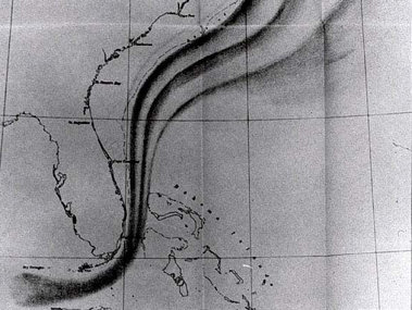
Tracking the Gulf Stream
The Gulf Stream is far more than a line on a map.
It is a powerful ocean current flowing past our own coastline, carrying about 32 million cubic meters of water every second through the Florida Straits. It helps shape weather in South Florida, influences climate across the Atlantic, affects marine ecosystems, and plays a role in storms, sea level, and global heat transport.
For students in West Palm Beach, the Gulf Stream is a reminder that the ocean is not separate from our lives. It is part of our local climate, our coastal environment, and our connection to the wider world.
The next time you stand at the shore and look east, remember: just beyond the beach, one of the greatest moving systems on Earth is flowing by.
Did You Know?
Pirates, Treasure Fleets, and Benjamin Franklin’s Gulf Stream Map
Tracking the Gulf Stream was not just important to scientists — it was important to explorers, merchants, and pirates too.
During the age of exploration, Spanish treasure fleets carried gold, silver, and other goods from the Americas back to Europe. Captains learned that by using the Gulf Stream, they could travel more quickly northward from the Caribbean and then head across the Atlantic.
But that created a problem: if sailors knew where the ships were likely to go, then pirates and privateers knew too. In other words, the Gulf Stream helped make some shipping routes faster — and more dangerous.
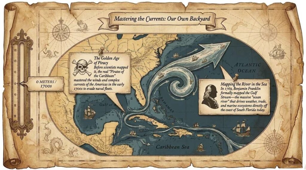
Later, Benjamin Franklin became interested in why some mail ships crossing the Atlantic were slower than others. Working with his cousin Timothy Folger, an experienced mariner, Franklin helped create one of the earliest maps of the Gulf Stream. That map helped sailors understand where the current flowed and how to use it more efficiently.
So the Gulf Stream has shaped not only climate and weather, but also trade, exploration, and even pirate history.